R
Reggie3cl
Guest
Route: Inverness to Inverness via Skye and Mallaig.
Straight out of Inverness to the south west there's a treat in store; the
A82 which runs down the side of Loch Ness. Assuming the grockles are
behaving themselves and you don't get stuck behind something big, there is serious fun to be had as this road
snakes down the side of chez Nessie in a series of 'does what is says on the
tin' bends that blend together
into a flip, flop, flip rhythm that is hypnotic. Don't doze off though,
there's a sheer rock face on one side and a 600 foot deep lake on the other!
At Invermoriston, about two thirds of the way down the loch, turn
off on to the to the A887 heading west. This road gradually climbs away from the loch and
out of the forests and away from civilisation (or towards it if you consider,
as I do,
an absence of speed cameras an important part of a civil society) into the
high country. By the time the turn off to
Invergarry is passed and the road changes name to the A87, the pace is really quick, but the undulations in the road can be a problem for a poorly set up machine. The signposts
(in English and Gaelic) point to the Kyle of Lochalsh and the Skye
bridge.
But before reaching the bridge there is one of the fastest and most
challenging
roads in Britain to tackle. Under big skies the sight lines are long and
the corners sweeping,
but the road bucks and twists like a snake on Mescalin and for twenty miles
there is no respite as you fight the bike to keep it on the black stuff,
but I challenge anybody with a temperature of 98.4 or above not to enjoy it.
Past the excellent Cluanie Inn (petrol here too) and down through Glenshiel
with the Five
Sisters of Kintail towering over you reach Loch Duich. Kintail Lodge is
right on the water and turned out to be an excellent place for the Scotish Rally in 2008.
Skirting the northern edge of Loch Duich the loch opens out a little and
soon
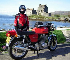
you're on the shore of Loch Alshe. Eileen Donan castle appears around a
corner, one of the most photographed landmarks in Scotland. Seen that film
Highlander? That's the one. A few small settlements with 40 limits calm things
down as you come in towards the Kyle of Lochalsh. The notorious toll has
gone, so it's over the bridge to Skye.
Now you're on Skye heading south to Armadale to catch the ferry to Mallaig on the mainland.
Most of the A851 between Broadford and Armadale has been improved- probably
with EU money. Well all hail Brussels, because it's as smooth as a billiard
table!
You can usually just roll up for the the Mallaig Ferry if you're on a bike-
it goes about once an
hour. But if you've just missed it there is a great little cafe on the
quayside. The indoor part is about as big as a garden shed, but it has a
lovely deck outside with outstanding views over the water to to Knoydart.
The crossing is beautiful and takes about twenty minutes on the new ferry.
Mallaig is a small and bustling fishing and ferry port. It lies at the northern end
of the 'Road to the Isles', otherwise known as the A830. Head south
on this
towards Fort William, past the white sands of Morar which look like
something from the Carribbean on a sunny day, then on to Glenfinnan. It's
worth a stop to photograph
the monument at the head of Loch Shiel where Bonnie Prince Charlie landed
in 1745 and raised his
standard to mark the beginning of the ill fated Jacobite Rebellion. This is
also where Harry Potter's Hogwarts Express was filmed steaming across the
railway viaduct.
The A830 has improved dramatically, although there are still some nadgery
sections single track (and lots of roadworks due to improvents) before reaching Corpach, just outside Fort William.
On the
left is Neptunes Staircase, a series of locks that are part of Thomas
Telford's
Caledonian canal which takes boats from the west coast to the east avoiding
the fearsome Pentland Firth between Caithness and Orkney.
Ben Nevis is to your right as you join the A82 heading north
up the Great Glen towards Fort Augustus. Another fabulous road in good
condition, although again the plague of dawdling tourists can hamper
progress. On the left, just north of Spean Bridge, we pass the Commando
Memorial marking the area where they trained during the second world war.
Fort Augustus is a pretty town at the southern end of Loch Ness with another
flight of locks running straight through the middle of it.
Here you can make the decision to take in more of the main route up the side
of Loch Ness by staying on the A82, or head towards Inverness by way of the
the southern side of the loch on the B862 which
is trickier (being single track) but less trafficked. This is made up in
part by General Wade's military road, built to allow rapid troop movements
around the Highlands in the aftermath of the Jacobite rebellion.. Many of
his bridges are dotted around the Highlands
Either way, thirty odd miles later we're back in Inverness after some 220
miles and around five hours travelling including stops and the ferry.
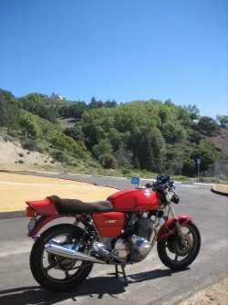
Sorry if this is a little over lyrical, but give me my Jota, a sunny day and
the route described and I'm in heaven!
Reggie
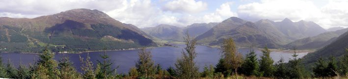
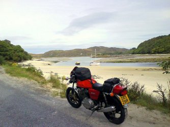
Pix below are First Born and Lav at Eileen Donan, Loch Duich and Glen Shiel from Mam Ratagan, Silver sands at Morar.
Straight out of Inverness to the south west there's a treat in store; the
A82 which runs down the side of Loch Ness. Assuming the grockles are
behaving themselves and you don't get stuck behind something big, there is serious fun to be had as this road
snakes down the side of chez Nessie in a series of 'does what is says on the
tin' bends that blend together
into a flip, flop, flip rhythm that is hypnotic. Don't doze off though,
there's a sheer rock face on one side and a 600 foot deep lake on the other!
At Invermoriston, about two thirds of the way down the loch, turn
off on to the to the A887 heading west. This road gradually climbs away from the loch and
out of the forests and away from civilisation (or towards it if you consider,
as I do,
an absence of speed cameras an important part of a civil society) into the
high country. By the time the turn off to
Invergarry is passed and the road changes name to the A87, the pace is really quick, but the undulations in the road can be a problem for a poorly set up machine. The signposts
(in English and Gaelic) point to the Kyle of Lochalsh and the Skye
bridge.
But before reaching the bridge there is one of the fastest and most
challenging
roads in Britain to tackle. Under big skies the sight lines are long and
the corners sweeping,
but the road bucks and twists like a snake on Mescalin and for twenty miles
there is no respite as you fight the bike to keep it on the black stuff,
but I challenge anybody with a temperature of 98.4 or above not to enjoy it.
Past the excellent Cluanie Inn (petrol here too) and down through Glenshiel
with the Five
Sisters of Kintail towering over you reach Loch Duich. Kintail Lodge is
right on the water and turned out to be an excellent place for the Scotish Rally in 2008.
Skirting the northern edge of Loch Duich the loch opens out a little and
soon
you're on the shore of Loch Alshe. Eileen Donan castle appears around a
corner, one of the most photographed landmarks in Scotland. Seen that film
Highlander? That's the one. A few small settlements with 40 limits calm things
down as you come in towards the Kyle of Lochalsh. The notorious toll has
gone, so it's over the bridge to Skye.
Now you're on Skye heading south to Armadale to catch the ferry to Mallaig on the mainland.
Most of the A851 between Broadford and Armadale has been improved- probably
with EU money. Well all hail Brussels, because it's as smooth as a billiard
table!
You can usually just roll up for the the Mallaig Ferry if you're on a bike-
it goes about once an
hour. But if you've just missed it there is a great little cafe on the
quayside. The indoor part is about as big as a garden shed, but it has a
lovely deck outside with outstanding views over the water to to Knoydart.
The crossing is beautiful and takes about twenty minutes on the new ferry.
Mallaig is a small and bustling fishing and ferry port. It lies at the northern end
of the 'Road to the Isles', otherwise known as the A830. Head south
on this
towards Fort William, past the white sands of Morar which look like
something from the Carribbean on a sunny day, then on to Glenfinnan. It's
worth a stop to photograph
the monument at the head of Loch Shiel where Bonnie Prince Charlie landed
in 1745 and raised his
standard to mark the beginning of the ill fated Jacobite Rebellion. This is
also where Harry Potter's Hogwarts Express was filmed steaming across the
railway viaduct.
The A830 has improved dramatically, although there are still some nadgery
sections single track (and lots of roadworks due to improvents) before reaching Corpach, just outside Fort William.
On the
left is Neptunes Staircase, a series of locks that are part of Thomas
Telford's
Caledonian canal which takes boats from the west coast to the east avoiding
the fearsome Pentland Firth between Caithness and Orkney.
Ben Nevis is to your right as you join the A82 heading north
up the Great Glen towards Fort Augustus. Another fabulous road in good
condition, although again the plague of dawdling tourists can hamper
progress. On the left, just north of Spean Bridge, we pass the Commando
Memorial marking the area where they trained during the second world war.
Fort Augustus is a pretty town at the southern end of Loch Ness with another
flight of locks running straight through the middle of it.
Here you can make the decision to take in more of the main route up the side
of Loch Ness by staying on the A82, or head towards Inverness by way of the
the southern side of the loch on the B862 which
is trickier (being single track) but less trafficked. This is made up in
part by General Wade's military road, built to allow rapid troop movements
around the Highlands in the aftermath of the Jacobite rebellion.. Many of
his bridges are dotted around the Highlands
Either way, thirty odd miles later we're back in Inverness after some 220
miles and around five hours travelling including stops and the ferry.
Sorry if this is a little over lyrical, but give me my Jota, a sunny day and
the route described and I'm in heaven!
Reggie
Pix below are First Born and Lav at Eileen Donan, Loch Duich and Glen Shiel from Mam Ratagan, Silver sands at Morar.
")