Weather where you are?

We live in a world of contrasts; the Adelaide Hills in South Aus have had less than 10 mm of rain this year, parts of North Queensland have had 500 mm in 24 hours.
 
chrisk said:
Have any of you snowed in, rained out, blokes ever think of moving to a better climate ............ NZ is a lovely place, and you'd be richer than you are now by 25%
What's happening Chris? An ocker promoting NZ! Something's wrong.
It should be noted that we only get 365 good riding days per year but some of them are a bit damp.
 
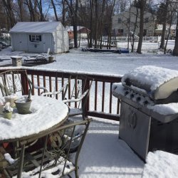
-30c  ( - 22f) with windchill for tonight. Worse part is most  of the snow is gone so no snowmobiling either. Ice on the lakes is close to 4ft thick( over a meter and 20cm) as the winter was really cold and little snow to insulate it.  Last year the motorcycles were out already. Where the hell is the global warming...send some to Manitoba Canada!
 
chrisk said:
Have any of you snowed in, rained out, blokes ever think of moving to a better climate ............ NZ is a lovely place, and you'd be richer than you are now by 25%.

Have a close look at the area at 4:26 ..... that's right, that's how it's pronounced ................ lucky tarmi

The Maori Wh - pronounced as an F...Rove did it to death I thought a few years back. Whakatane is within reach of 3 circuits quite easily too.

It's actually been a bloody weird summer over here. Very early spring leading into a drought. Then before Christmas, enough rain to cause quite a bit of flooding, incl here... Now, a mild autumn. I was actually out on the rideon today mowing the acres, and it was warm and dry. Around this time last year the local ski fields were looking at opening early....
I'll take the warm weather while it's here - it's drying the winter's firewood nicely.
 
Legs said:
We live in a world of contrasts; the Adelaide Hills in South Aus have had less than 10 mm of rain this year, parts of North Queensland have had 500 mm in 24 hours.
Ain't that the truth Terry.
We have Tropical cyclone Iris hovering around just off shore here. A lot of people jittery as it is just over 12 months since TC Debbie did considerable damage to the area, much of which is still not repaired >:( :o
Fortunately this one is not expected to cross the coast, just get near enough to dump more rain and gale force winds. They expect it to head slowly south for next couple days then head East, although some thought as it intensifies may double back and start a new trajectory!!
Have had buckets of rain over last few weeks so everything is water logged at present so every time we get a quick downpour of 100mm or so, we get a bit of flooding :o.
Hopefully "Iris" will do the right thing and follow the expected models and move on out to sea without creating too much damage........................  :-\
 
chrisk said:
It's just that we don't need anymore here.  ;)

Peter, Iris shouldn't affect you too mush will she?
Hmmm, well we're being belted with gale force winds and shitloads of rain, so will depend largely on how much closer she comes. Later tonight and tomorrow probably tell the story how much (or whether) cyclonic winds we get. At present Iris is expected to intensify, but then, hopefully turn East and be downgraded. Shouldn't get a direct hit like last couple of times, but you have to prepare as they can change their minds! At this stage, flooding is main issue, although Prossie is used to being cut off (& neglected by the media ::)). I wouldn't expect too much structural damage, although there is some concern about unidentified weaknesses caused from Debbie. Of course waterlogged ground will no doubt see some trees down.
Haven't even lost our power yet ;)
Should all be fine, just another day in paradise...............
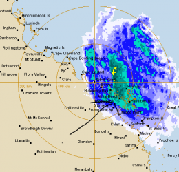
Edit :-Just as a matter of interest this is snip of current radar image of the storm. I am sure everyone knows, our cyclones move in a clockwise direction, so you can picture this storm currently moving south and rotating clockwise so bottom left edge is the leading edge. Arrow marks roughly where Proserpine is.....
 

Attachments

  • TC iris at 345pm Tues 3 Apr.PNG
    TC iris at 345pm Tues 3 Apr.PNG
    31.5 KB · Views: 3
Could you send just a little bit of that rain down here Pete, the rain water tanks are just about dry.
 
The meteorologists saying: "The only thing you can predict about a cyclone is it?s unpredictability". Bastards of things.
Stay safe, I hope it recurves and heads back out to sea. Those warm sea temperatures are a problem though.
 
Got an ex-submariner mate at Airlie Beach, he was clobbered last time, hope he doesn't get hit again.
 
henrywillms said:
-30c  ( - 22f) with windchill for tonight. Worse part is most  of the snow is gone so no snowmobiling either. Ice on the lakes is close to 4ft thick( over a meter and 20cm) as the winter was really cold and little snow to insulate it.  Last year the motorcycles were out already. Where the hell is the global warming...send some to Manitoba Canada!

I can't say i feel your pain totally ..... but this whole winter thing has been very fucked up for the past 2 years. The scientists will tell us that it is an an anomaly and 2 years doesn't mean anything ........ but i suspect they don't live in Canada.

Hope to see you someday Henry ...... Laverda's across Canada will happen!
 
When thinks go 'tits up' with the weather in North America we tend to get similar in the UK.
Of course things change a little as the systems work their way across the Atlantic and we don't necessarily get the extremes.

We had a very DRY Autumn and early Winter, with reservoirs at around 30% capacity.
Our local water authority in Kent applied for a preliminary drought order at Christmas, the ink wasn't even dry on the document, then it pissed down for months and got very cold - an uncommon mixture around these parts (tends to be wet and warmer or dry and cold in the winter).
The drought order has only just expired, not that we took it seriously as every time they get one it pisses down anyway.

It looks like spring is weeks late this year, with only a hint of budding on the trees.
 
Late Spring this year in Denmark, where we had yet another 10-15 cm of snow the day before yesterday, and some donut spread a continents worth of salt on every single road. Ggrrrr......  >:(

But where there is hope, there is a way, and finally Spring time seems to get it's way tomorrow with a sudden +10 degrees c.

Hopefully, as I really look forward to getting the SFC out again ;)
Cheers,
Jacques
 
Looks like TC Iris is going to behave herself. It is remaining at sea and has not intensified further, so just causing a bit of havoc with wind and rain. It is now forecast to move a bit further south and be downgraded further to a Low by tomorrow morning. Our only problem will be that when it becomes a low it is forecast to turn and head back this way, so looks like more rain (& wind) for quite a few more days yet.
 
SimonR501 said:
SNIP

It looks like spring is weeks late this year, with only a hint of budding on the trees.

Hi Simon

nothing at all budding out here as yet, usually golf courses open and hardy motorcyclists out by mid March most years, looking more like late April this year at the very earliest...... :(

Paul LeClair
 
Paul LeClair said:
Hi Simon

nothing at all budding out here as yet, usually golf courses open and hardy motorcyclists out by mid March most years, looking more like late April this year at the very earliest...... :(

Paul LeClair
A late spring for us Northern Hemisphere types then Paul.
We now have the first hints of a change the last two days. The sun is out and so are the bikers.
 
Back
Top