Go West young man...........

Shajota

Hero member
Location
Whitsundays Qld
I had been wanting to do a quick trip out West again for some time and with Marty’s round Aus trip back on decided to head to Blackall to coincide with their visit on day 5. Plan was to take a couple of days to get there and a couple back travelling mainly on back roads so didn’t expect to do more than about 600ks each day so sounded a perfect trip for the American Eagle.
I have written the following report which I tried to do a bit differently and acknowledge is a bit wordy, so understand if you just scroll to the piccies......

Motto for the trip, the less people the better.

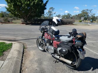
Tuesday morning I set off on a beautiful clear winter’s day and the Eagle is ticking along nicely. Down the highway through the canefields, veer off to Mirani then up the Eton range and onto Nebo for fuel. Grabbed a sandwich from the gastronomic selection of 3 in the fridge and an hour or so down the “Beef” road stopped in a nice quiet spot to sample the ham & salad delicacy along with a nice cup of coffee. Ahh, the peace and serenity:-
1.JPG
A couple of hours later after getting fuel at Dysart decided to take some back roads toward Clermont. First two low level causeways I came to had crashed cars in the creek beds obviously from driving (probably at speed) into recent floodwaters. (Causeways were on blind curves and no safe place to stop and take a pic)

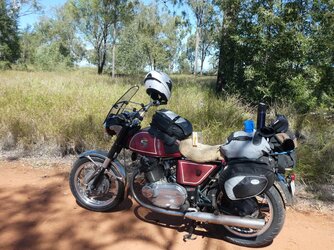
Meandered through cattle country with the road largely to myself and had a brief stop to admire the Lords Table Mountain. (Picture doesn’t do it justice)
2.JPG
Eventually had to reluctantly turn onto the Gregory Highway and head to Emerald for the night. After a day cruising dreamingly I Suddenly realised I had to increase my speed to avoid being mowed down by the trucks although to be fair there wasn’t that many. Interestingly hardly any caravans on the roads I had just travelled but quite a few now!
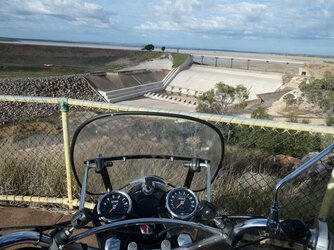
Leaving Emerald next morning thought I’d take a quick trip out to see how much water was in Fairbairn Dam. Fairbairn dam is a large earth filled embankment dam that services the needs of the local area’s significant broadacre cropping, including cotton, wheat, sorghum etc plus the urban requirements of a number of small nearby towns and of course leisure activities for the locals which includes a large mining population. I was surprised how low the dam was however I am unfamiliar with its usage patterns so just a quick ponder, a shake of the head and off. You can get to the dam via a loop road that crosses the dam and back to Emerald on the western side. For some reason I love it when dam walls are accessible to the public and love riding across them (am I weird?)
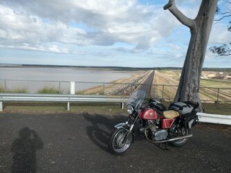
3.JPG
4.JPG
Fuel up and head west, next stop Jericho. I am sure many are a bit surprised at a small western town having a biblical name such as Jericho. To complete the picture it is worth mentioning that Jericho (Qld) is built on the river Jordan and is situated South of a semi arid salt lake called Lake Galilee😆 In 1988 a Bicentennial project was completed to further cement these rather dubious religious links. The project was a sculptural display called the Crystal Trumpeters in the park bordering the road through town. The Crystal Trumpeters apparently depicts the story of the original Jericho as per a book of the bible. Perhaps we have some theologians at heart who would better understand all of this however I just find the silliness of it highly amusing and I love this type of quirkiness which crops in many Western areas. Nevertheless, I decided to have a rest near the Crystal Trumpeters and absorb some of the biblical goodwill no doubt available:-
7.JPG
Next road I was keen to take was also a new one on me and was a 120km direct link from Jericho to Blackall which had finally been fully sealed earlier this year to offer a more direct cattle transport route. Caution signs were up however the road was one of the best I had travelled on. There were no line markings however the road was wide and surface flat. Only met 2 cars and one cattle road train in the whole distance so a very enjoyable little jaunt. It is worth mentioning that not long down this road the sun was over my right shoulder and cast a shadow of the bike just to my left front. I happened to glance down and noticed the shadow of the headers and something dangling in between! No doubt my horn, so quickly pulled up and sure enough the support bracket had broken clean off and the horn was dangling happily by one wire held with a push on spade connecter. A very lucky save. Standing there I felt a calming breeze and ignoring all the heathens I realized this was a sign the Crystal Trumpeters were riding with me and providing some good fortune😇😆

Made it to Blackall without further incident, Blackall is proud of its name:-
8.JPG
Met up with Martys round Australia crew at the Barcoo hotel where the beers were cold, the bar “people” agreeable and the food was tasty.
The saying is there is effall in Blackall so 3 old Laverdas and an old Guzzi parked behind the Barcoo must be rare:-
12.JPG
We did have to grab a table fairly early because the grey nomads were out in this part of the world en masse. The free camp on the banks of the Barcoo river was packed:-
9.JPG
........................................................................................................................................................................................................................................................................................TBC
 
Last edited:
Outstanding, good to see you had the blessing of the Crystal Trumpeters. (y)
They can be finicky as to who they bless....
 
Ok day 3 - Overnight rain at Blackall which had soaked everything left on the bikes had cleared and looked like fine conditions for those heading North however a line of storms was heading due East and another system was bringing rain to the Rockhampton area. Looked like I was going to get wet.

I wished the boys well and hi tailed it back up the Jericho road wanting to get to Rockhampton on the coast by day’s end. (I met 1 car and 1 truck on the return 120kms to Jericho!)

By the time I arrived at Emerald about 350kms away I had nearly caught the rain band however a quick check of the radar showed it was slowly slipping away to the South. It was obvious I was missing some very heavy falls with a lot of surface water on the road and also in the towns particularly around Blackwater and Bluff but I was just getting spray off the road and slight drizzle. The Trumpeters were still with me, although we were pushing it!!
13.JPG
I eventually made it to Rocky however weather there was pretty grim and I wanted to get to the Northside for a quick departure the next day. Driving through town it was rainy, wet and very dark, not the greatest conditions for the Grimeca drums. (Did I mention I hate cities.) Made it safely to my destination and had a couple of tasty Monteith Blacks while I spread out the wet gear and watched the footy.

Next morning by the time I repacked, the skys had cleared after heavy overnight and morning rain.
Wet roads but clear skys, happy days..............

About 30kms along the road I glanced in the mirror and couldn’t see the edge of the sheepskin seat cover I had strapped to a rear bag to dry out. Pulled up and sure enough it was gone. Secured the now loose strap and noticed that the weather had once again closed in and looked like I was heading straight into rain. 70kms further on coasting into Marlborough to fill up the Eagle suddenly lost power and I had to replace the main fuse but couldn’t find a reason why. After losing the sheepskin, now this, I felt an eeriness and suddenly it hit me, the Crystal trumpeters had retreated back to Jericho and I knew why!!

The plan today was to turn left at Marlborough and take the old Marlborough - Sarina road. This road was no place for the low level goodness the Crystal Trumpeters from Jericho on the banks of the Jordan river in Qld could offer, so it was just me and the Eagle!

If I still have any readers this far please indulge me while I explain the history of this stretch of road which is one of the original “Badlands” roads of Australia.

The Marlborough to Sarina Road was formerly part of National Highway 1 until the early 80’s when the new coast road was finally opened and this stretch became a secondary road used mainly by local traffic and cattle trucks. The old stretch has had many nicknames, such as “Crystal highway”, “Murder road” and the “Horror stretch” however everyone we knew when growing up just called it the "Marlborough stretch" and those words were enough to elicit a sense of foreboding, evil and heightened awareness. The “Crystal highway” name was quite benign and used in earlier years because of the amount of shattered glass from broken windscreens that littered the roadside.

“Murder road” and the “Horror stretch” are more ominous nicknames and relate to the fact that in the 50’s, 60’s & 70’s a number of random murders, unexplained disappearances and other violent acts occurred along this road. Couple this with Poor road safety and treacherous conditions in wet weather (both explained later) and the names are well deserved.

We used to pile in the back of the Holden station wagon and travel this road quite often in school holidays to visit relatives in Mackay and there was always a sense of adventure, trepidation and a military preparation for the trip to ensure no unscheduled stops.

The unwritten rule of the stretch was no stops except to get fuel at one of the roadhouses presumably because at any given spot there would be someone camped behind a tree waiting to ambush the unwary and slit their throats without a second thought:eek:

Over the years perhaps some incidents have been overstated or embellished but I reckon folklore is great. Embrace it and it enhances any trip!

Another feature of the road was the amount of abandoned vehicles along the way, some broken down and left (perhaps the driver murdered), but most rolled and crashed, a result of too much speed on the uneven road surface. The stretch was a favourite for the brave to try and set a point to point time and with bravado heightened by a six pack or 3 of your favourite tipple would often see cars launched out of a dipsy doo and end up rolling into the scrub. You would also see a number of caravans along the way that had obviously crashed after swaying out of control on the bumpy road. The caravans usually ended up just a flattened mess of rubble.

Now it should be said, rules are made to be broken and if we came across a reasonably fresh pile of caravan wreck the old man would pull the EK over and we would search through the wreckage looking for a special window winder or some sort of cover which you couldn’t get anymore. Our searches usually proved fruitless however we would always end up with a couple lengths of aluminium which would “come in handy later.” Presumably those stops were allowed because no self respecting murderer or bandit would be hiding near a wrecked caravan!

Another famous condition of this road was the number of low level single lane bridges that dotted the Northern end. Great care had to be taken in the wet season as these bridges were prone to regular flooding and it was very easy to get caught stranded between them for days on end. Quite a regular occurrence back in the day and names such as Lotus Creek, Connors River and Funnel Creek were usually names associated with unpleasant experiences.

So what is the road like today? TBC
 
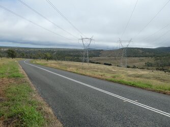
The condition of the road is better than I remember and toward the southern end there are a number of construction areas and work camps which suggests the road is making a comeback. There is a range at the southern end (yes, Mildred we do have corners!!) and it appeared to be in better condition than last time I travelled it on a motorcycle. Going up the range I went into low level cloud and very limited visibility however on the other side came out into good clear conditions and panoramic vistas of the plains which seemed to suggest that the evil had left the area many years ago and perhaps the Trumpeters simply because they had nothing further to do. Another notable modern feature is the grid of power lines now criss crossing the land obviously providing power to the ever expanding and power hungry Drag lines working the coal mines to the west (ironic?):-
14.JPG
Two of the old roadhouses are used as private residences or farm sheds and the old car wrecks are long gone. The road today is a very pleasant drive in the country and does not resemble the desolate image from years ago. Still not a lot of cars travel this road, mainly locals or work vehicles and I didn’t cross paths with any caravans so they obviously avoid. In 2001 a monument was erected at Croydon Station to recognize the route the Olympic flame travelled on the way to the 1956 Melbourne Olympics. The plaque mentions the “unique” conditions which I think refers to the heat and wet weather and road conditions suffered by the relay runners along this Mackay to Rockhampton leg which had to be detoured via Croydon Station due to weather:-
15.JPG
The 250km stretch of road previously had 3 roadhouses however once the new highway was opened only one remained (Lotus Creek) however it was destroyed in the floods after Cyclone Debbie in 2017.
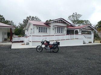
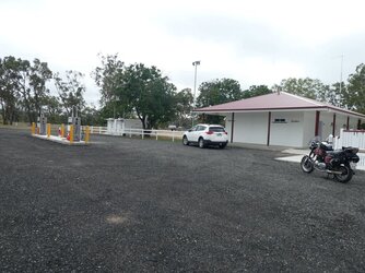
I was looking forward to getting to Lotus Creek where I intended to take a shot of the bike parked in the forecourt of the now derelict and destroyed roadhouse. Imagine my surprise when rounding a bend and dropping down to the single lane bridge over Lotus Creek I looked up and there appeared a vision of all new buildings. I was dumbfounded and did a couple of circles before pulling into the driveway. There was no signage or indication of this new facility however while I was standing beside the bike the owner came out and explained that it had only been opened about 10 days and they were still sorting out teething issues (Internet for eftpos being a major one which is not surprising) and had not advertised the facility anywhere. There were new petrol pumps, a new flash amenities block and they had transported a 90yo homestead from Murgon to be used as the shop / restaurant. It was all freshly painted and in beautiful condition but anyone filling up didn’t even know where to pay as it appeared to be just a house:-
17.JPG
16.JPG
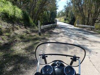
I was a bit down heartened as this was final confirmation that the Horror stretch reputation was surely dead and the mystic gone. After a bit more fuse trouble I was on my way again and I did perk up a bit when the road north, while well sealed, was still very bumpy and uneven and the low level single lane bridges were still there in all their glory. Care still needs to be taken at these bridges as approaches are often blind and best erring on the side of caution when meeting a fully loaded cattle truck coming the other way. This was always a problem when this was highway 1 and a major freight corridor. Connors river and Funnel Creek are actually lovely little oasis but of course are treacherous areas in the wet season and many people have horror stories of being trapped on one of their banks. Connors River:-
18.JPG
Funnel Creek:-
19.JPG
I was always going to turn back inland before Sarina to avoid the Bruce highway as long as possible as I knew the Oxford Downs road was one of the few properly developed links between the old stretch and the Peak Downs Highway which would take me straight back to Nebo and the final leg home. Nebo:-
20.JPG
Fuel up and a Friday pie at Nebo and the Eagle continued humming on the 190km stretch home arriving in time to have a couple of tinnies while unpacking and still finding some wet gear and having a good look for the vague electrical gremlin. I also reattached the horn which was pretty much the total extent of problems on the trip. The Eagle is a great back roads tourer and averaged 56mpg over the 2200kms travelled over the 4 days in what was just a quick trip out West detouring along many of the roads less travelled.
Many don’t see these as great motorcycling roads but I love the wide open spaces and the lack of traffic and there is plenty to see. Congratulations to anyone who managed to read this far through the drivel. I hope I have peaked some interest in travelling alternate routes away from the madding crowds.
 
Last edited:
Great write up. Love the back roads, especially a bit of dirt. Murder Road. There's a few of them out there, especially a bit further east. More than a few people have gone off. Went to School with Mark Jones, Tony's brother, who went missing at Hughenden in '82. They are pretty certain who his murderers are. Tony was a great kid in a hard working, tight knit family. No angels looking after him then. I still catch up with Mark. They are not giving up having the 2 blokes that did it behind bars.

There's some dangerous creatures on this continent alright. Wolf Creek's Mick Taylor a choir boy by comparison.
 
Great report Peter,

rekindled my memories of the Malborough to Sarina road when I first travelled there in 1970 and again in 72.
Everybody in southern QLD warned of impending doom.
We have a lot of lovely country away from the coast, and even tho us grey nomads - you are one of us you know - do take up the best camping/caravanning sites, at least we get out and see this great place we call home.
 
What a great read - gives a real insight into the roads and area. Thanks.

Envious about your lack of traffic. In the UK it feels like we see more vehicles in a hundred feet than you seem to get in a hundred miles.
 
Great read, thanks. In a nutshell just what it is all about for many of us, especially we who know the terrain and roads in that area. It goes to show that you don't need a bells and whistles two wheeled SUV either.
 
I had been wanting to do a quick trip out West again for some time and with Marty’s round Aus trip back on decided to head to Blackall to coincide with their visit on day 5. Plan was to take a couple of days to get there and a couple back travelling mainly on back roads so didn’t expect to do more than about 600ks each day so sounded a perfect trip for the American Eagle.
I have written the following report which I tried to do a bit differently and acknowledge is a bit wordy, so understand if you just scroll to the piccies......

Motto for the trip, the less people the better.

Tuesday morning I set off on a beautiful clear winter’s day and the Eagle is ticking along nicely. Down the highway through the canefields, veer off to Mirani then up the Eton range and onto Nebo for fuel. Grabbed a sandwich from the gastronomic selection of 3 in the fridge and an hour or so down the “Beef” road stopped in a nice quiet spot to sample the ham & salad delicacy along with a nice cup of coffee. Ahh, the peace and serenity:-
View attachment 65068
A couple of hours later after getting fuel at Dysart decided to take some back roads toward Clermont. First two low level causeways I came to had crashed cars in the creek beds obviously from driving (probably at speed) into recent floodwaters. (Causeways were on blind curves and no safe place to stop and take a pic)

Meandered through cattle country with the road largely to myself and had a brief stop to admire the Lords Table Mountain. (Picture doesn’t do it justice)
View attachment 65069
Eventually had to reluctantly turn onto the Gregory Highway and head to Emerald for the night. After a day cruising dreamingly I Suddenly realised I had to increase my speed to avoid being mowed down by the trucks although to be fair there wasn’t that many. Interestingly hardly any caravans on the roads I had just travelled but quite a few now!
Leaving Emerald next morning thought I’d take a quick trip out to see how much water was in Fairbairn Dam. Fairbairn dam is a large earth filled embankment dam that services the needs of the local area’s significant broadacre cropping, including cotton, wheat, sorghum etc plus the urban requirements of a number of small nearby towns and of course leisure activities for the locals which includes a large mining population. I was surprised how low the dam was however I am unfamiliar with its usage patterns so just a quick ponder, a shake of the head and off. You can get to the dam via a loop road that crosses the dam and back to Emerald on the western side. For some reason I love it when dam walls are accessible to the public and love riding across them (am I weird?)
View attachment 65070
View attachment 65071
Fuel up and head west, next stop Jericho. I am sure many are a bit surprised at a small western town having a biblical name such as Jericho. To complete the picture it is worth mentioning that Jericho (Qld) is built on the river Jordan and is situated South of a semi arid salt lake called Lake Galilee😆 In 1988 a Bicentennial project was completed to further cement these rather dubious religious links. The project was a sculptural display called the Crystal Trumpeters in the park bordering the road through town. The Crystal Trumpeters apparently depicts the story of the original Jericho as per a book of the bible. Perhaps we have some theologians at heart who would better understand all of this however I just find the silliness of it highly amusing and I love this type of quirkiness which crops in many Western areas. Nevertheless, I decided to have a rest near the Crystal Trumpeters and absorb some of the biblical goodwill no doubt available:-
View attachment 65073
Next road I was keen to take was also a new one on me and was a 120km direct link from Jericho to Blackall which had finally been fully sealed earlier this year to offer a more direct cattle transport route. Caution signs were up however the road was one of the best I had travelled on. There were no line markings however the road was wide and surface flat. Only met 2 cars and one cattle road train in the whole distance so a very enjoyable little jaunt. It is worth mentioning that not long down this road the sun was over my right shoulder and cast a shadow of the bike just to my left front. I happened to glance down and noticed the shadow of the headers and something dangling in between! No doubt my horn, so quickly pulled up and sure enough the support bracket had broken clean off and the horn was dangling happily by one wire held with a push on spade connecter. A very lucky save. Standing there I felt a calming breeze and ignoring all the heathens I realized this was a sign the Crystal Trumpeters were riding with me and providing some good fortune😇😆

Made it to Blackall without further incident, Blackall is proud of its name:-
View attachment 65077
Met up with Martys round Australia crew at the Barcoo hotel where the beers were cold, the bar “people” agreeable and the food was tasty.
The saying is there is effall in Blackall so 3 old Laverdas and an old Guzzi parked behind the Barcoo must be rare:-
View attachment 65078
We did have to grab a table fairly early because the grey nomads were out in this part of the world en masse. The free camp on the banks of the Barcoo river was packed:-
View attachment 65075
........................................................................................................................................................................................................................................................................................TBC
Dont mind a Dam wall myself Peter.......Probably ride across Sugarloaf dam wall, more than i should.
That Qrt mile strip at Emerald looks luvverly.
Great trundle out in the Boonies!
:oops:
 
Met up with Martys round Australia crew at the Barcoo hotel where the beers were cold, the bar “people” agreeable and the food was tasty.
The saying is there is effall in Blackall so 3 old Laverdas and an old Guzzi parked behind the Barcoo must be rare:-
There's a man who went out
In flood time and drought
To the banks of the outer Barcoo
....BP

What a great read, the bike looks great and by your own account was the perfect mount for the ride, yes the fewer bells and whistles the better.

Very interesting that the names Jericho, Jordan, and Gallilee appear in outback Australia, I have visited all 3 albeit in Israel maybe one day I'll get to them down south there.
On Jericho and the story of the golden trumpets bringing down the walls of the city, well it is a good tale. Biblical archeologists, of which my wife is, determined that the Israelites lay siege to Jericho trying to starve out the Pagan occupiers. The siege lasted for over a year during which the Israelites tunneled under the outer walls weakening the structure. Knowing that the walls were about to fall the Israelites for one week marched around the outer walls of Jericho playing musical instruments in an effort to warn the occupiers of the pending doom. The warning was ignored so a bit more digging and the walls crumbled.
 
Thanks for this write-up Peter! Different conditions compared to Europe, but indeed very interesting. E.g. areas with "horror stretch reputation" are rather unknown to us ...
:)
 
Thanks all for the comments, thought it might have been a bit much, but just tried to portray the "feel" as the pics may not be as spectacular as elsewhere;)

rekindled my memories of the Malborough to Sarina road when I first travelled there in 1970 and again in 72.
Everybody in southern QLD warned of impending doom.
We have a lot of lovely country away from the coast, and even tho us grey nomads - you are one of us you know - do take up the best camping/caravanning sites, at least we get out and see this great place we call home.
Ha ha, let you into a little secret David. We have a caravan as well and I am always trying to find great camping spots, but my missus gets a bit unnerved when I find a remote one where no one else is:LOL:
 
Back in the late 70s I stuffed the SF2 into the armco on the Sarina bends heading to Mackay and totaled the front end.
Got to Makay in the back of a ute and the bike onto a train back to Melbourne. I started hitch hiking back to Melbourne as I had no money left for a train ticket for myself. I was hoping to get some work in Mackay in the cane fields to carry on but no bike made it impossible to get to the cane fields so had to retreat back to Melbourne. I was told in Mackay if I got a lift make sure it went through to Rockhampton and not get stranded in between on the Marlborough stretch. So bang in the middle of the Marlborough stretch the guys says I'm turning right here, a little gravel road heading to where ever the fuck it went. So standing on the side of the road in midday heat no shade or water it took ages to get another lift for obvious reasons. Eventually a truck driver picked me up and got me to Brisbane. I had quite alot of gear, helmets, riding gear etc and I had to haul that walking towards a mates place to within my few remaining dollars for a taxi fare to my mates place. Fuck hitch hiking back to Melbourne so borrowed enough from my mate for a flight back.
 
Last edited:
Great write up. Love the back roads, especially a bit of dirt. Murder Road. There's a few of them out there, especially a bit further east. More than a few people have gone off. Went to School with Mark Jones, Tony's brother, who went missing at Hughenden in '82. They are pretty certain who his murderers are. Tony was a great kid in a hard working, tight knit family. No angels looking after him then. I still catch up with Mark. They are not giving up having the 2 blokes that did it behind bars.

There's some dangerous creatures on this continent alright. Wolf Creek's Mick Taylor a choir boy by comparison.
I'll tell a little story from personal experience of the time.
To set the background....
In 1978 a bloke on a gs750 and a couple on a BMW r100s (flash newish bikes) set off from Alice Springs planning to head to Cairns then down to Melbourne. A few weeks after they left they were found in bushland West of Mt Isa shot dead!!!! Crime is still unsolved although they are pretty sure who did it as they found one of the bikes in his possession. At the time it was widely reported they just thought it was an opportunistic killing and even a suggestions it was a random truckie.
So, about 6 months after this in1979 me and a mate did a ride we had planned to the Northern Territory (me on a Honda 4 and mate on a Ducati Dahrma) We head to Alice Springs then Ayers Rock (rough corrugated dirt road at that time but that's another story) reverse back & head up to Darwin (where we realised NT Draught didn't taste nice like we thought when we had it Barrow Creek on a hot arvo!) then home to Qld.
On the way home somewhere East of Camooweal my mate wanted to stop to adjust some gear. This is an isolated spot with bugger all trafficand we had just pulled onto the side of the road. I am just standing there when I see a trucking coming toward us. My mate's nearly finished when a flat bed semi trailer pulls up right beside us in the middle of the Rd. I am watching this bloke as he gets out. He makes no effort to acknowledge us or even look at us, just walks around the front of the truck, opens the passenger door and starts doing something behind the seat. My blood ran cold and I thought, fuck me he's putting bullets in a magazine, gonna pull out a rifle and shoot us stone dead in the middle of nowhere! I turn to my mate and said let's get out of here. He looked and said what. I said get going, NOW, he got the message & we quickly put on our helmets and took off.
Now, I am sure he was just looking for a packet of milk Arrowroot biscuits he was going to offer to us with some fresh Billy tea but his actions and the recent triple murder not too far from where we were put the wind right up me and I'm not too worried we didn't wait to find out.....
And that your honour is the honest truth!!
 
Yikes! I've done a few solo rides out that way. My epic wet season trip from Lismore to Darwin in 1975 was one - the isolation due to me getting through floods that no others could might have saved me from grief at the hands of the Wake in Fright or Wolf Creek brigade!
 
And I have hitched (and ridden) those roads numerous times, even been dropped off in the middle of the Marlborough stretch at midnight (after being driven to a Blackfella camp in woop woop my mate and me offered work as tree ringbarkers), and never had a problem, although the rumours were alive at the time. Some of the locals were great, friendly helpful people. Weirdos are everywhere. The ranges to the west have some fantastic spots to visit.
 
Back
Top